Uber gives cities free travel-time data
SAN FRANCISCO — Uber is going to make urban traffic and mobility data gleaned from its millions of drivers and riders using the Uber app freely available to all.
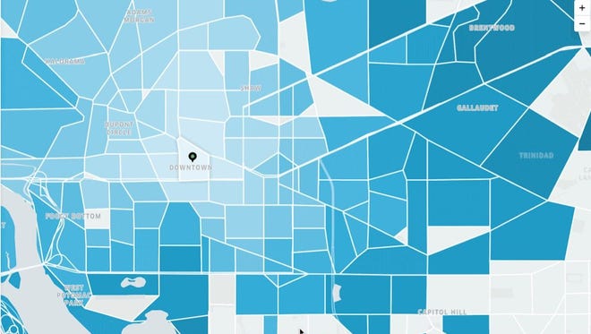
The data, which shows anonymized travel times between points in cities, will be available on a public website called Uber Movement.
Uber says it will first invite planning agencies and researchers to access the information and then make the website free to the public. The first cities will be Washington D.C., Manilaand Sydney.
The San Francisco-based company decided to release the data when it realized it had “this very valuable but untapped resource for understanding a city’s transportation infrastructure,” said Andrew Salzberg, Uber’s head of transportation policy.
Pegged to a transportation conference in DC on Sunday, the release is also likely is a bid to gain some goodwill with cities, with which Uber has often had bare-knuckled fights over regulation.
The announcement comes as Uber, Lyft and other ride-hailing companies face demands from cities that they provide more information about their riders — demands they have long opposed.
The most recent square off is in New York City, where New York’s Taxi & Limousine Commission will hold a public hearing on Thursday a demand that Uber give the city information about where and when drivers drop off passengers, something taxi drivers already are required to do.
Uber Movement doesn't map individuals rides, but rather segments of rides, focusing on travel time between specific points, Gilbertson said.
“We’re using ride data as a proxy, we’re taking periodic GPS trace pings during the rides,” he said.
For example, the Uber data showed changes in travel times in the Washington D.C. area when parts of the regional Metro were shut down for repairs.
The Uber data will give cities a low-cost way to do high-resolution travel time analysis. Robust traffic data of the sort needed by planners is often either expensive or out-of-date.
“For us in the planning context, it’s very interesting," said Jascha Franklin-Hodge, Boston’s chief information officer.
“Oftentimes, cities and state transportation systems use things like toll transponders to show how long it takes to get from one place to another. But those are on fixed routes. What’s interesting is this allow us to look at a lot of different routes,” he said.
The Uber data makes it possible to reliably estimate how long it takes to get from one area of a city to another by analyzing multiple trips over time.
To protect the privacy of Uber drivers and passengers, only areas with relatively high tip volume are included. Otherwise it might be possible to track the movement of a unique individual if only a few Uber trips went through a specific area in a given time.
On the maps, Uber grays out areas where trip numbers are too low to protect driver privacy.
The company has been beta testing the program with Washington D.C. The data will initially be available for a limited number of cities which will be added to over time. Uber currently is active in 450 cities worldwide.
While the data isn’t comprehensive enough to allow city planners to rely solely on it, it will be helpful. It also should be a boost to public engagement with planners, said Boston’s Franklin.
“This gives people tools to ask us questions. That’s really powerful. We believe in having an informed public and having conversations that are rooted in facts, so the more of facts that are available, the better,” he said.